©The image generated by Magic Media.
Wind Energy
Conflict-free planning
Where should the many wind turbines that Germany needs to be greenhouse gas neutral by 2045 be located? The German government has set itself this target in order to curb the consequences of man-made climate change. However, wind energy has been expanded far less than would actually be necessary for years. There are many reasons for this, ranging from a lack of public acceptance of wind turbines to conflicts with nature and species conservation and problems with noise and shadow flicker. The result: not enough potential areas are designated for the construction of new wind turbines and the construction of already planned wind turbines is often delayed due to lengthy legal proceedings.
In the WindGISKI project funded by the Federal Ministry for the Environment, L3S scientists are working with other partners from science and industry to investigate how artificial intelligence (AI) can help to find new areas with low conflict potential. One of the first questions the researchers asked themselves was: Which characteristics are relevant for the evaluation of areas and how can we obtain data from all over Germany efficiently and comprehensively? As the characteristics come from different areas, the expertise of the entire interdisciplinary team was required. The partners used different data sources for the individual characteristics: for example, they contacted authorities, analysed lawsuits, interviewed experts and carried out immission simulations. The data obtained was then collated in a geographic information system (GIS). This GIS dataset is constantly being expanded to improve data quality. The AI uses this data to make predictions, which can then be analysed again using GIS.
“One particular problem is the lack of a measurable target value,” says Daniel Gritzner, who is responsible for developing the AI-based model for predicting potential areas at L3S. “Typically, you train an AI by repeatedly showing it positive and negative examples. In this case, it’s a difficult task because we can’t simply use existing wind farms and free areas.” Some wind farms would no longer be built in this way today due to changes in the legal framework. They are therefore not suitable as a positive example. The approach also assumes that there are still suitable free areas. “So not every area without a wind farm is a negative example. And we actually want to predict something like a construction project realisation speed or probability as a target value. However, this cannot be determined across the board.” The scientists now want to solve this particular challenge with their model.
The GIS enriched with AI predictions is intended to support users in their decision-making. Therefore, another aim of the project is to make the AI predictions comprehensible for industry experts, who are usually not AI specialists. The researchers also realised early on that the success of a wind energy project also depends on social factors such as public acceptance. An accompanying handout is therefore intended to show GIS users ways of realising site designations and projects in a way that is as socially and environmentally compatible as possible.
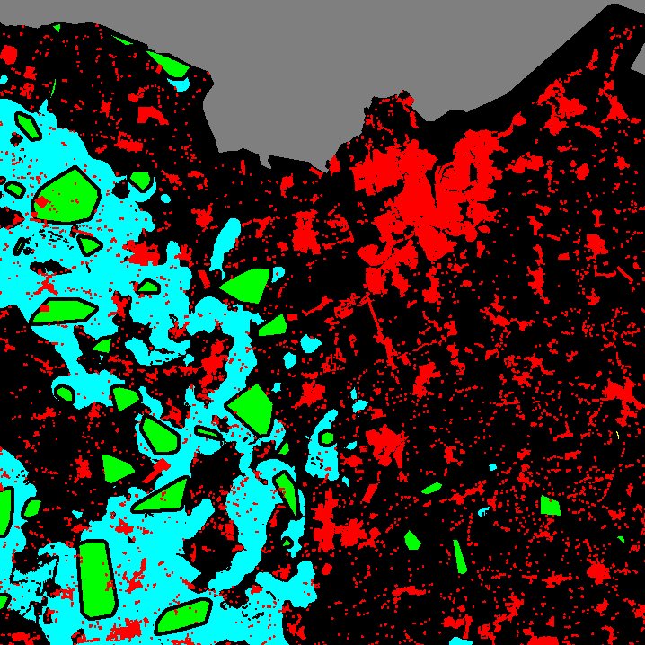
An extract from the north of Schleswig-Holstein with an incomplete data set. Due to the difficult starting situation for model training, the AI currently suggests (cyan) that existing wind farms (green) in particular should be expanded instead of developing new areas as in the eastern part of the extract. Unused areas are black; red areas have a hard exclusion criterion, e.g. residential buildings.
Featured Projects

Contact
Prof. Dr.-Ing. Jörn Ostermann
Jörn Ostermann is a member of the L3S and heads the Institute for Information Processing at LUH. He conducts research in the field of signal processing with a focus on video, sequencing and audio data.

Dipl.-Inf. Daniel Gritzner
Daniel Gritzner is a PhD student at the Institute of Information Processing. In addition to his work in WindGISKI, he also conducts research in the field of semantic segmentation of aerial and satellite images.